Hydrology
MCW Hydrology of the Mekong, led by Dr. Yadu Pokhrel and PhD student Huy Dang, studies the hydrology of the Tonle Sap Lake (TSL) in Cambodia. The TSL is Southeast Asia’s largest inland lake that supports one of the world’s largest inland fisheries, which has seen substantial hydrological changes between 2000 and 2016 impacting both socioeconomic and environmental conditions of the region. These adverse impacts are related to the changes in the Mekong mainstream flood pulse due to upstream dam construction. While the dams have benefited communities in the Lower Mekong River Basin by increasing the region’s overall capacity for irrigation, water resources management, and power generation, there are growing concerns that hydropower and irrigation dam operations, especially when combined with climate change impacts, are causing fundamental shifts in the hydrology and inundation dynamics of the TSL.

There are three main objectives of our studies including:
- Examine the changes in the mainstream Mekong flood pulse and the Tonle Sap River (TSR) flow reversal.
- Quantify the alterations in the water balance of the TSL.
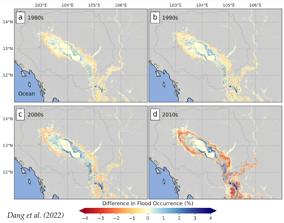
- Investigate the changes in flood occurrences in and around the lake.
The modeling framework used in our studies comprises two models: CaMa-Flood-Dam (Catchment-based Macro-scale Flood-plain, version 3.94, with modified reservoir operation scheme) that simulates river-floodplain-reservoir hydrodynamics and the global hydrological model HiGW-MAT (Human Impact and Ground Water Modules in MATSIRO) that takes meteorological forcing data from WFDEI (WATCH Forcing Data using the ERA‐Interim) database to simulates runoff required as input in CaMa-Flood-Dam. The models compute river-floodplain hydrodynamic properties (i.e., river discharge, water level, and inundated areas) of the entire Mekong River Basin at ~5km resolution (simulated inundated area is downscaled to a higher resolution of ~90m) for 38 years (1979-2016) under the following settings: (1) natural simulation without considering dams (NAT), and (2) regulated simulation by implementing dams based on their commissioned year (DAM).
There are three main key findings in our studies as follows:
- While climate variability has been a key driver of the inter-decadal variabilities in the lake’s hydrology, the Mekong dams have exerted a growing influence over time—more pronouncedly after 2010—on the Mekong flood pulse, the TSR flow reversal, and TSL water balance and its inundation dynamics.
- Dams had dampened the annual amount of water exchange between the TSL and Mekong mainstream, especially in the 2010s, the inflow from the Mekong to the TSL has reduced by 10-25%.
- The inner area of the lake stays inundated longer, while the outer peripheral area is drained more quickly. The annual inundated duration of this area is reduced by ~15 days, which effectively shrinks the lake’s seasonally inundated areas.
If you are interested in this work, you can read our peer-reviewed publication on the topic.